ePrivacy and GPDR Cookie Consent management by TermsFeed Privacy Policy and Consent Generator BC-1.12 Arenas Negras

BC-1.12 Arenas Negras

BC-1.12

Icod de los Vinos-Garachico, extensión de la ruta BC-1 hacia el Área Recreativa y Zona de Acampada Arenas Negras.

Description

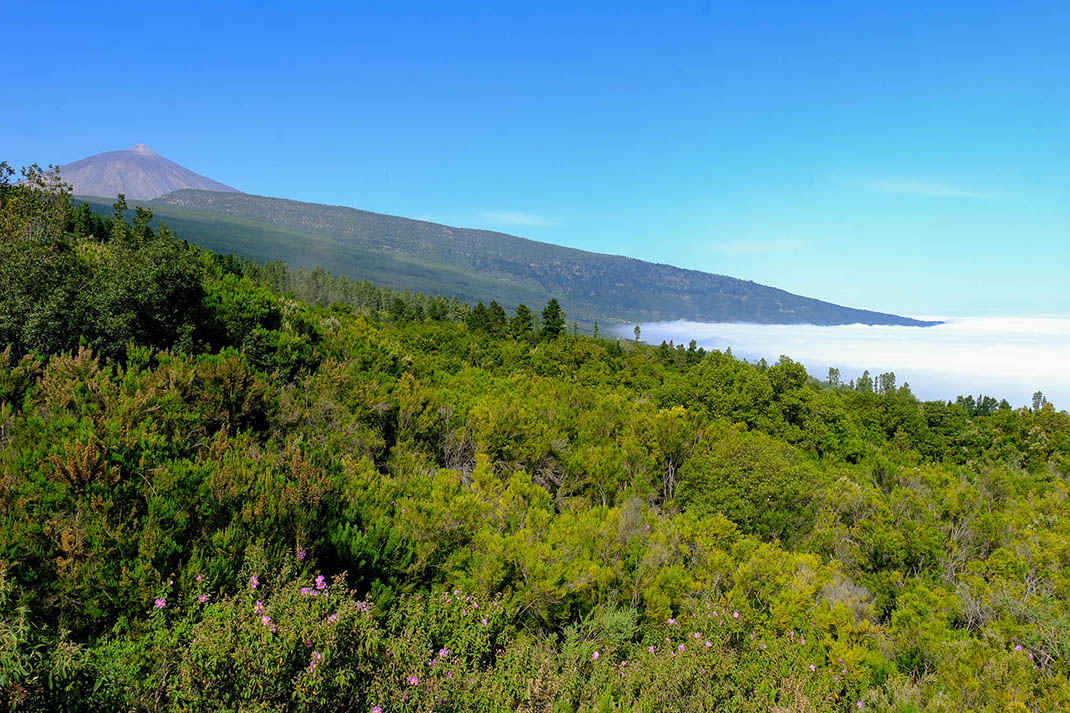
This trail brings you up close to the impressive volcanic landscape of Garachico, dominated by the contrasting colours of the vegetation and the terrain. 

The route runs along the Canal and the Arenas Negras trail in parallel with the Canal de Vergara, the longest aqueduct on the island at 34km long, and ends at the Arenas Negras Recreational Area. 

In this area you will be able to enjoy the beautiful volcanic landscape created by the eruption of the Montaña Negra or Garachico volcano in 1706, which destroyed the town of Garachico, the most important port on the island at that time.

A forest of Canary Island pine trees sits on top of the “picón” (volcanic lapilli) and lava flows, their blackened trunks bearing testimony to the huge forest fire of 2007. Here you will find huge pine trees, classified as monumental trees, such as the famous “Tres Pernadas”, made up of three immense trunks. At the same time, in the undergrowth you can find fayas (Morella faya), codesos (Adenocarpus viscosus) and jaras (Cistus symphytifolius).

Tips

  • Always stay on the marked trail and do not enter private property, hunting grounds, water galleries, wells or caves.  
  • Be careful when walking along roads used by motor vehicles and hiking trails, and when crossing ravines with water courses.
  • Avoid direct encounters with potentially dangerous animals, such as livestock, beehives, and dogs. 
  • Proceed with caution and watch for obstacles, loose rocks, uneven terrain or steep slopes to avoid accidents and falls. 
  • Consult our good practice guide and, if necessary, contact emergency services by calling 112.
Recommendations and tips

Guides

No data available

Permits

  • Reservation obligatory for groups organised by for-profit and not-for-profit public and private entities and profit-making individuals. Link
  • T: 901 501 901 - 922 239 500.
  • Free access for all other users, alone or in a group, no reservation required.

Technical information sheet

Route information

Cycling and horse riding route

8,35 km

2 h 15 m *

123,79 m

253,94 m

*At an average speed of 4 km/h

  • Altitude gain:123,79 m

  • Altitude loss:253,94 m

  • Maximum altitude:1.362,04 m

  • Minimum altitude:1.228,65 m

Signage

Route code

BC-1.12

Orange posts and signs that include:

  • Official trail number.
  • Route direction.
  • Distance to points of interest.
  • Cyclist and horserider icons.
Signage

Route map and profile

Elevation profile

  • Maximum altitude:1.362,04 m

  • Minimum altitude:1.228,65 m

Connections with other routes

  • /

How to get to route start point

Route BC 1, starts at the Canal trail, from the Llanos del Hospital trail, Icod de los Vinos.

No nearby service.

No parking spaces in the area.

How to get to route end point

Arenas Negras Recreational Area, Arenas Negras/General Garachico trail, Garachico.

No nearby service.

Parking spaces available in the Arenas Negras Recreational Area.

Municipalities passed through

  • Garachico
  • Icod de los Vinos

Protected Areas

Transit

Parque Natural de la Corona Forestal

The Corona Forestal is the largest protected natural area in the Canary Islands, one of the most extensive forests on the islands, the lungs of Tenerife and the gateway to Mount Teide.  As its name ...

Discover the Protected Area
Parque Natural de Corona Forestal

Weather

Today, tuesday, in Icod de los Vinos


Clouds
Wind

3 km/h

Temperature

17ºC Maximum

13ºC Minimum

Rain

166%

3 day forecast

wednesday

16ºC Maximum

13ºC Minimum

thursday

17ºC Maximum

14ºC Minimum

friday

16ºC Maximum

14ºC Minimum